Jebel El-Kelaa
Jebel El-Kelaa, Tanger-Tetouan-Al Hoceima, Morocco
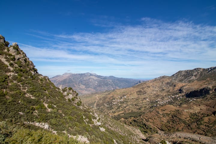
Rif landscape
View from pass below Jebel El-Kelaa
Bab Taza, Chefchaouen, Morocco
The first thing I found on my way to the top of Jebel El-Kelaa was the driving school. In a little park just up the hill from Chefchaouen, Moroccan men in tiny compact cars were busy practicing three-point turns and parallel parking, gingerly weaving their way through a mini-maze of traffic cones.
Jebel El-Kelaa, a modest 1616m peak that rises above Chefchaouen, is not one of the world’s most celebrated mountains. Perhaps for that reason, information about how to climb it is relatively scarce. Fortunately, I had found two helpful guides: How to Hike Jebel El-Kelaa by Uneven Tenor, and How To Summit Jebel El-Kelaa by Gordon Alexander. They were both somewhat pessimistic about my chances of finding my way without their help: Uneven Tenor observes that most descriptions of the hike ended with the words “after a few hours we were lost, so we went home”.
Even with the guides to lean on, I quickly found that I had strayed from the path they probably wanted me to take. Quite soon, what I was seeing no longer bore even a passing resemblance to the useful photographs in the guides. I was not, however, lost. I knew this because I had followed Mr Alexander’s advice and downloaded Maps.me. At least on the screen of my iPhone, my route to the summit looked clear.
It was also rather less than direct. Maps.me in its wisdom wanted me to follow the freshly-graded road that circles the mountain. As the alternative was to strike off blindly uphill and, no doubt, go charging straight through someone’s kif fields (the Rif Mountains are one of the great cannabis-growing regions of the world). I decided to follow the newly-constructed path of least resistance, a broad stripe of dirt flanked on either side by huge earth berms and, at one point, a very large and pungent dump.
After a three-quarter orbit of the mountain, I found myself at the starting point of my ascent. The broad road spawned a muddy side-trail, which eventually dumped me at the foot of a steep slope covered with boulders of various sizes and even more mud. I scrambled up what I took to be the path, checked my map and discovered that I was already about a hundred meters from the suggested route. I turned and began to pick my way awkwardly across the hillside.
I passed a good part of the next hour like that – finding the path, then losing it again, then finding it once more. To my surprise, I discovered that there was actually a trail of sorts, and it had even been blazed. In places, the balisage was unambiguous: superimposed white and yellow stripes. Elsewhere, however, the trail markers consisted of round white splotches of paint dabbed seemingly at random on prominent rocks. Unfortunately, these marks were exactly the same size, shape and color as the round white splotches of lichen that decorated every rock in the vicinity. I spent quite a lot of time scrambling uphill toward what I thought was the next marker, only to discover that it was just another patch of lichen and that I was, once again, well off the trail.
After a lengthy period of picking my way painfully up the steep and slippery slope, I arrived at a kind of narrow saddle between two peaks. Jebel El-Kelaa rose on my right; another jebel loomed to my left, and the main path dropped away into a wooded valley ahead of me. I stopped and admired the view of the surrounding mountains – which was spectacular – and then started on the final part of the ascent.
Around this point, the anonymous trail marker appeared to have thrown up their hands and said “Screw it, I’m done”. The basic direction was clear enough: all I needed to do was keep climbing and eventually I’d reach the top of the mountain. The devil, however, was in the details. This final slope was not only even steeper, but the mud had given way to dense, thorny scrub. I set off uphill, lost my way, clawed my way painfully back across the hillside, found what Maps.me insisted was the path, and then got lost again. Lather, rinse, repeat.
If I had to choose one word to describe the ascent of Jebel El-Kelaa it would probably be ‘tedious’. Or maybe ‘frustrating’. It isn’t a particularly difficult climb, but it makes up for its lack of technical challenges by offering a great many small annoyances in the form of mud, scrub, and steeply-inclined scree slopes that seem to have been purpose-built to reduce your uphill progress to a sometimes literal crawl. It is a difficult mountain to love.
In compensation, however, the view from the top is not bad. To one side, Chefchaouen is suddenly visible again, a splash of blue and white that trails away downslope. On the other sides, there are only mountains. While the Rif are less spectacular than the High Atlas, they’re real mountains, and quite attractive in their own right. Ravens tumbled and barked in the open air above my head, and fast-moving clouds marched along the ridgelines. I began to feel more warmly toward Jebel El-Kelaa.
My new-found fondness for the mountain lasted about a quarter of the way down the scrub-covered slope that led to the saddle. The descent was, if anything, more unpleasant than the climb. By the time that I was halfway down the muddy part – and now amply-covered with mud myself, having slipped and fallen a few times – I was back to hating the mountain again. I plodded onwards, ignoring the protests of my knees, switch-backing my way downslope toward the road. Dull as the road might be, at least it was more or less level.
At last – having taken a poorly-considered shortcut that led me across someone’s extremely muddy field and through an arroyo – I found myself back on the road. I ate some celebratory bread and cheese, then shouldered my daypack and set out for Chefchaouen.
About half a kilometer farther on, I met two teenage girls in headscarves. “Comment tu t’appeles?” the bolder of the two asked. We exchanged names and a few pleasantries, and then I waved goodbye and walked on, only to be stopped by a sharp “Monsieur!!!” from behind me. I turned to see what the girl wanted. “I lahve yoo!” she exclaimed, and then collapsed in a fit of giggles. Her companion, visibly dying of mortification, elbowed her in the ribs. “I lahve yoo!” the girl insisted. I considered telling her that I loved her too, but that our parents would never consent to our union, then decided against it. For all I knew, a verbal contract might be binding under Moroccan law, and I had no wish to find myself the centerpiece of a Berber shotgun wedding with a sixteen-year-old bride. I waved to them again and marched on, the intermittent shouts of “Monsieur!!! I lahve you!” growing slowly fainter behind me.
About a half-kilometer from Chefchaouen I stopped to admire an entire flock of white storks perched on a rock outcrop overlooking the road. They were handsome birds, and they seemed quite unafraid as I stood there taking pictures of them. We watched each other for a while, and then the storks lifted ponderously into the air and flapped across the road to resume scavenging in the garbage dump on the other side.